
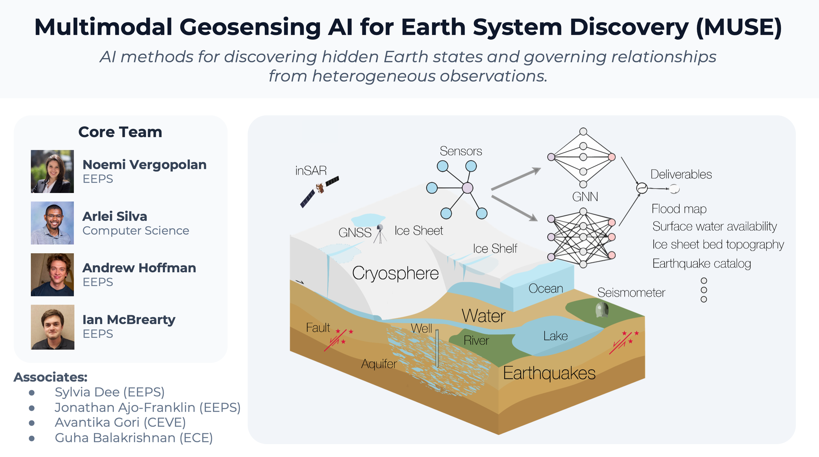
Earth systems are changing in ways that directly affect society, making it difficult to monitor and understand issues with water availability, flooding, sea levels, and earthquakes. At the same time, scientific data streams produce fragmented observations that differ in spatial resolution, measurement frequency, uncertainty, physical meaning, and geographic coverage. The Multimodal Geosensing AI for Earth System Discovery cluster develops multimodal geosensing AI methods to integrate diverse Earth observations—such as satellites and seismic networks—to discover hidden Earth states and governing relationships for water resources, floods, and geophysics.
Cluster Members
- PI: Noemi Vergopolan (CEE)
- Co-Is: Arlei Silva (CS), Andrew Hoffman (EEPS), Ian McBrearty (EEPS), Nakul Garg (ECE)
- Associates: Sylvia Dee (EEPS), Jonathan Ajo-Franklin (EEPS), Guha Balakrishnan (ECE), Avantika Gori (CEE)
-
Research Vision
-
Earth systems are changing in ways that directly affect society, with water availability becoming harder to predict, floods intensifying in many regions, ice sheets contributing to sea level rise, and earthquakes remaining difficult to monitor and understand. At the same time, scientists now have unprecedented data streams from satellites, drones, radar, seismic networks, distributed acoustic sensing, GPS/GNSS, hydrologic sensors, and physically-based numerical models. These observations are powerful but fragmented. They differ in spatial resolution, measurement frequency, uncertainty, physical meaning, and geographic coverage. As a result, many critical Earth states remain hidden or poorly constrained, such as groundwater storage, soil moisture, flood extent and flow pathways, subsurface water movement, ice-sheet basal conditions, vertical land motion, earthquake source processes, and evolving fault behavior.
Our vision is to establish Rice as a leader in multimodal geosensing AI by developing artificial intelligence methods that integrate diverse Earth observations to discover hidden states, governing relationships, and missing physical processes. The goal is not to replace physics with AI, but to develop AI systems that incorporate known physics and learn from observations more effectively, thereby improving prediction, forecasting, and generalization capabilities. This includes foundation models that learn reusable and scale-adaptive representations across sensor types, graph neural networks for irregular sensor networks and spatial systems, physics-informed machine learning, uncertainty quantification, and equation-discovery methods that can reveal simple and interpretable relationships within complex Earth data.
The cluster will build collaborative research around four societally relevant scientific testbeds:
Water, led by Noemi Vergopolan, will focus on soil moisture, groundwater recharge, surface water, drought stress, and water availability, which are systems difficult to model because they involve hidden water storage, nonlinear interactions with land cover and topography, and sparse observations.
Flood dynamics, led by Arlei Silva, will develop graph-based AI methods for learning how water moves across connected landscapes, including rivers, drainage pathways, floodplains, terrain, and sensor networks, which can be represented as dynamic graphs.
Cryosphere and sea level geophysics, led by Andrew Hoffman, will use graph-based methods to invert for the physical properties of ice sheets and poromechanical aquifers. Both systems shape sea level rise and coastal change, yet the processes that control their dynamics occur beneath Earth’s surface, where direct observations are limited.
Earthquakes, led by Ian McBrearty, will focus on seismic detection, phase association, source localization, and the use of irregular seismic and geodetic sensor networks to better understand active Earth processes.
Across these testbeds, our cluster will develop graph-based and multimodal AI methods. Graph AI is central because many geosensing problems are not naturally organized as images or regular grids. For example, seismic stations and rivers form networks of connected systems, satellite pixels interact across space and time, and subsurface processes are observed only indirectly. By treating geosensing data as dynamic multiscale graphs, we will develop foundational AI models that capture the underlying physics of complex systems and transfer across domains.
The cluster focuses on scientific discovery from heterogeneous observations to (i) integrate data across sensors and scales, (ii) infer hidden Earth states, (iii) discover governing relationships or model corrections, and (iv) quantify where predictions are reliable or underconstrained. Our unique contribution is to make geosensing itself the foundation for AI discovery by building transferable methods that learn across water, floods, ice, land motion, and earthquakes from observations with different physics, geometries, and uncertainties. Methodologically, it will advance multimodal AI, graph learning, physics-aware foundation models, surrogate models, and equation discovery for complex scientific data. Societally, it will improve knowledge of water resources, floods and droughts, sea-level and land-surface change, and earthquake systems. MUSE fills a distinct gap in Rice’s research ecosystem by bringing together strengths in climate risk, scientific machine learning, and multimodal AI through a focused, cross-school effort in geosensing-driven Earth system discovery, led by a young faculty team with demonstrated success in geoscience, AI, and their intersection.